前回の港の歴史①では、
今よりずっと海岸線が南にあった、
古代「鵜足津(うたづ)」の姿を思い描いてみました。
続いては、宇多津が最も輝いていた(!?)中世の歴史を振り返っていきます。
In the previous installment of The History of the Port (Part 1), we envisioned the ancient landscape of “Utazu,” a time when the coastline extended much further south than it does today.Now, let us turn our attention to the Middle Ages, a period when Utazu was at its peak (or so it seems!?), and explore its historical significance.
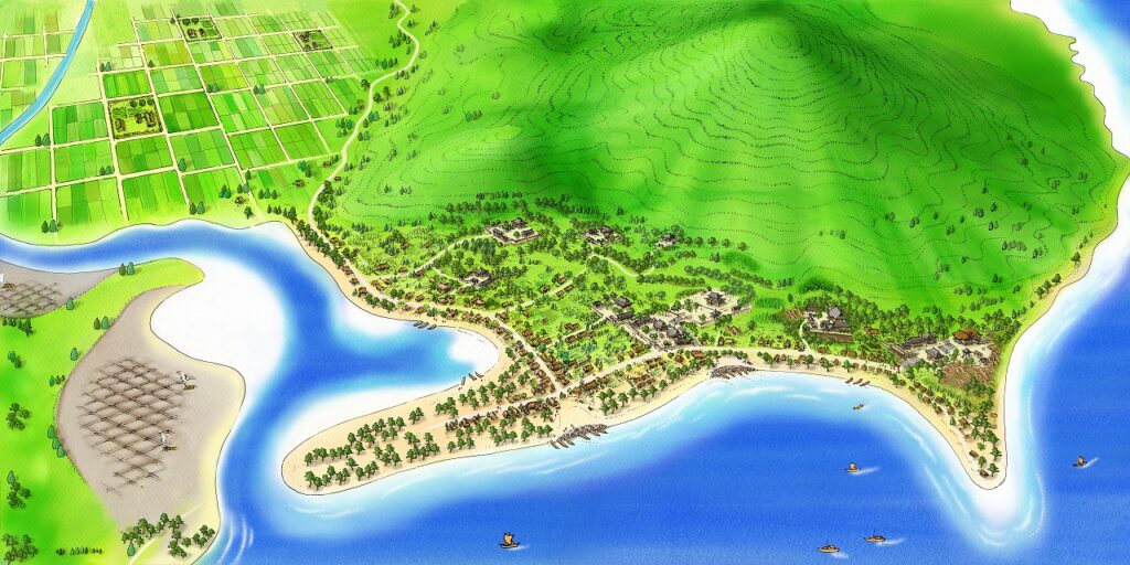
海岸線が北上し陸地が出現!
畑さん
古代より都と讃岐をむすぶ海運の重要な拠点として栄えた宇多津。
中世に入ると海岸線が北上し、
現在の宇多津古街とほぼ同じ範囲が陸地として出現しました。
The Coastline Shifted North, Revealing New Land!
Hata-san
Utazu flourished as a key maritime hub connecting the capital with Sanuki since ancient times.As the Middle Ages began, the coastline moved northward, and land emerged, covering an area roughly equivalent to today’s historic district of Utazu.

引用元:Google社「Google マップ」を基に作成。青線が中世の海岸線(推定)
古代には青の山の南側にあった港も、
海岸線の変化とともにやや北上。
聖通寺(しょうつうじ)山と青の山に挟まれた湾のような部分と、
海岸沿いの2ヶ所にあったと考えられています。
In ancient times, the port was located on the southern side of Aonoyama. However, as the coastline shifted, it gradually moved northward.
It is believed that the port existed in two locations: one in a bay-like area nestled between Shōtsūji-yama and Aonoyama, and another along the coastline.
西本さん
2つの山に囲まれていて船を着けやすかったんですかね。
畑さん
浅い入り江がラグーンのようになって重宝したようですね。
Nishimoto-san
Being surrounded by two mountains, I wonder if it made docking ships easier.
Hata-san
It seems that the shallow inlet functioned like a lagoon, making it a valuable harbor.
「海に開かれた都市」展図録より(香川県歴史博物館)
中世、宇多津はもっとも輝いていた…!?
井村さん
この頃になると、瀬戸内海の海運はより活発になるんじゃないでしょうか?
畑さん
そうですね。瀬戸内海は今でいうところの「高速道路」でした。
下関を抜け、愛媛県沖の伊予灘(いよなだ)から都に向かう船は、
瀬戸(せと:島が多く流れの速い入り組んだ海域)と
灘(なだ:島が少なく流れの穏やかな広い海域)とを
交互に経ながら進んでいきます。
急流の備讃瀬戸(びさんせと:岡山県と香川県の間の瀬戸)を越える前に、
多くの船が宇多津で一休みしていたのかもしれませんね。
1445年の兵庫北関(きたのせき)入船納帳によれば、
宇多津を発した多くの船が北関まで入船していたとの記録が残っています。
宇多津は大きく繁栄し、
寺社なども多数立ち並ぶ力のある街になっていきました。
大岩本さん
当時、宇多津にはお寺が…確か最大30カ寺でしたか?
畑さん
はい。
小さな街ながら驚くほどたくさんの勢力が集まっていたんですね。
Was the Middle Ages the Golden Era of Utazu!?
Imura-san
By this time, maritime activity in the Seto Inland Sea must have become even more active, don’t you think?
Hata-san
Yes, exactly. The Seto Inland Sea functioned much like a modern highway.
Ships traveling from Shimonoseki, passing through the Iyo-nada off the coast of Ehime, and heading toward the capital would navigate through alternating sections of Seto—narrow, fast-flowing straits with many islands—and Nada—broader, calmer waters with fewer islands.
Before crossing the turbulent Bisan Seto—the strait between Okayama and Kagawa—many ships likely stopped at Utazu for a brief rest.
According to the 1445 Hyōgo Kitanoseki Ship Register, numerous ships departing from Utazu were recorded as arriving at Kitanoseki, suggesting that Utazu was a major hub of maritime traffic.
As a result, the town flourished, becoming a thriving center with a significant number of temples and shrines.
Oiwamoto-san
At its peak, Utazu had… was it as many as 30 temples?
Hata-san
Yes. Despite being a small town, it attracted an impressive concentration of influential groups.
天下統一、しかし宇多津は…
畑さん
その後、豊臣秀吉による四国平定後の1587年、
生駒親正(いこまちかまさ)公が讃岐国を与えられます。
親正公がまず考えたのは、本城をどこに置くかということでした。
宇多津にはすでに聖通寺城がありましたが、
本城としては手狭だったこと、
また直近で2度城主が改易(かいえき)※となっていたので、
親正公としてはその城をそのまま使うのは心象があまり良くなかったんではないでしょうか。
※城主の所領を罰として没収、減封、転封すること
玉井さん
かといって、新たに城をつくって城下町を置いて…というには、
やっぱり宇多津の街は少し狭いですよね。
加えて、繁栄していたが故に旧来からの寺社勢力も多いですから、
新しく来た親正公にとってはいわば脅威とも言えますよね。
畑さん
そうですね。
旧勢力の力を弱めることは親正公にとっても大きな関心事でした。
結局、本城は高松市に(=高松城)、
支城は丸亀市に(=丸亀城)置かれることになり、
宇多津は政治の中心からは外れてしまいました。
しかも築城の際に宇多津にあったいくつもの寺社が、
檀家ごと高松や丸亀に移動させられてしまったんです。
横田さん
この頃から宇多津の繁栄に少し陰りが見えてきた…という感じでしょうか。
畑さん
そうかもしれませんね。
一方で、その名は世界にも知られていた可能性もあるんですよ。
The Unification of Japan—But What Happened to Utazu?
Hata-san
After Toyotomi Hideyoshi’s conquest of Shikoku, Chikamasa Ikoma was granted control of Sanuki Province in 1587.
One of his first priorities was deciding where to establish his main castle. Although Shōtsūji Castle already existed in Utazu, it was too small to serve as a primary stronghold. Additionally, the fact that two previous lords had recently been removed (kaieki) likely made it an undesirable choice for him.
Kaieki: The confiscation, reduction, or reassignment of a feudal lord’s domain as a form of punishment.
Tamai-san
But building a new castle and developing a castle town from scratch would have been difficult, especially given Utazu’s limited space.
On top of that, because the town had long been prosperous, it had a strong presence of established religious institutions. From Chikamasa’s perspective, those existing power structures could have been a potential threat.
Hata-san
Exactly. Weakening the influence of the old religious factions was a significant concern for him.
In the end, he chose to establish Takamatsu Castle in present-day Takamatsu City as his main stronghold, while Marugame Castle was built as a secondary fortress in Marugame. As a result, Utazu was no longer a political center.
Furthermore, many temples and shrines in Utazu were forcibly relocated to Takamatsu and Marugame, along with their parishioners.
Yokota-san
So, would you say that this was when Utazu’s prosperity began to decline?
Hata-san
That might be the case. However, it’s also possible that Utazu’s name was known beyond Japan during this time.
宇多津は世界デビューしていた…かもしれない
畑さん
キリスト教の宣教師と共に船で日本を巡っていたMoreira(モレイラ)という人物が、
1617年に記したとされる日本地図に宇多津の名が出てきます。
Did Utazu Make Its World Debut?
Hata-san
A man named Moreira, who traveled around Japan by ship alongside Christian missionaries, created a map of Japan in 1617. Interestingly, the name Utazu appears on this map.
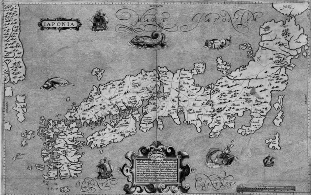
ブランクス/モレイラ「日本図」 https://www.zenrin.co.jp/museum/permanent/chapter01/
そこで宇多津は、「Sanuqui(サヌキ)」の港として
唯一「Vtangra(ウタングラ)」と記載されています。
On this map, Utazu is the only port labeled as “Vtangra”, representing Sanuki (Sanuqui).

ブランクス/モレイラ「日本図」(部分) https://www.zenrin.co.jp/museum/permanent/chapter01/
「-angra(アングラ)」はスペイン語で「入り江」の意味。
「Vta(ウタ)」+「angra(アングラ)」、
つまり「鵜足(うた)」+「津(つ)」という地図を
世界の人も見ていたのかもしれません。
石川さん
驚きました。
やはり昔から、宇多津はそのぐらい開けた、栄えた街だったんですね。
“-angra” is a Spanish word meaning “bay” or “inlet.”
Thus, “Vta” (Uta) + “angra” (Angra) likely represents “Utazu” (鵜足津)—
suggesting that people around the world may have seen this name on the map.
Ishikawa-san
That’s incredible. It really shows that Utazu was already a well-developed and thriving town in those days.
港の歴史③ につづく
To be continued in The History of the Port (Part 3)